SpatialCollection
Next version — This documentation describes a major version that is not yet the current stable release of spatial-types.
What is a SpatialCollection?
A SpatialCollection groups spatial objects, potentially of different types, into one value. It can also contain nested collections. The immutable variants are named GeometryCollectionImmutable and GeographyCollectionImmutable.
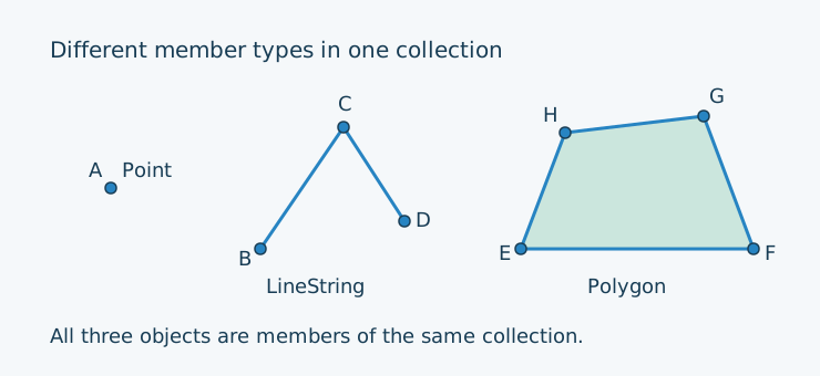
SpatialCollection — Supported representations
Availability in the current version of Spatial Types:
| Coordinate layout | Geometry Mutable | Geometry Immutable | Geography Mutable | Geography Immutable |
|---|---|---|---|---|
| XY | ✅ | ✅ | ✅ | ✅ |
| XYZ | ✅ | ✅ | ✅ | ✅ |
| XYM | ✅ | ✅ | ✅ | ✅ |
| XYZM | ✅ | ✅ | ✅ | ✅ |
Mutable representations use SpatialCollection; immutable representations use
GeometryCollectionImmutable or GeographyCollectionImmutable.
Creating the illustrated objects
The examples recreate the labelled objects above using Geometry in XY. Composer’s autoloader must already be loaded. Variable names match the point letters in the illustration.
Immutable objects
<?php

use LongitudeOne\SpatialTypes\Types\Dimension2\Geometry\PointImmutable;
use LongitudeOne\SpatialTypes\Types\Dimension2\Geometry\LineStringImmutable;
use LongitudeOne\SpatialTypes\Types\Dimension2\Geometry\PolygonImmutable;
use LongitudeOne\SpatialTypes\Types\Dimension2\Geometry\GeometryCollectionImmutable;

// Immutable objects must be fully initialized through their constructors.

$a = new PointImmutable(10, 13);
$b = new PointImmutable(23.5, 7.5);
$c = new PointImmutable(31, 18.5);
$d = new PointImmutable(36.5, 10);
$e = new PointImmutable(47, 7.5);
$f = new PointImmutable(68, 7.5);
$g = new PointImmutable(63.5, 19.5);
$h = new PointImmutable(51, 18);

$line = new LineStringImmutable([$b, $c, $d]);
$ring = new LineStringImmutable([$e, $f, $g, $h, $e]);
$polygon = new PolygonImmutable([$ring]);
$collection = new GeometryCollectionImmutable(elements: [$a, $line, $polygon]);
Mutable objects
<?php

use LongitudeOne\SpatialTypes\Types\Dimension2\Point;
use LongitudeOne\SpatialTypes\Types\Dimension2\LineString;
use LongitudeOne\SpatialTypes\Types\Dimension2\Polygon;
use LongitudeOne\SpatialTypes\Types\Dimension2\SpatialCollection;

$a = new Point(10, 13);
$b = new Point(23.5, 7.5);
$c = new Point(31, 18.5);
$d = new Point(36.5, 10);
$e = new Point(47, 7.5);
$f = new Point(68, 7.5);
$g = new Point(63.5, 19.5);
$h = new Point(51, 18);

$line = new LineString([$b, $c, $d]);
$ring = new LineString([$e, $f, $g, $h, $e]);
$polygon = new Polygon([$ring]);
// Using the constructor.
$collection = new SpatialCollection(elements: [$a, $line, $polygon]);

// Alternatively, adding members with methods.
$collection = new SpatialCollection()
    ->addElement($a)
    ->addElement($line)
    ->addElement($polygon);